Satellite images show unique desert lakes

By Han Junhong in Changchun and Zhou Huiying | chinadaily.com.cn | Updated: 2022-07-04 17:17
Share
Share - WeChat
A photo taken by the Jilin-1 satellite shows a lake in the Badain Jaran Desert of Alshaa League of the Inner Mongolia autonomous region. [Photo by Changguang Satellite Technology/For chinadaily.com.cn]

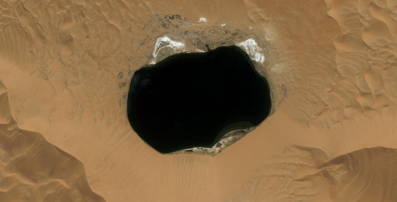
The satellite family, developed by Changchun-based Changguang Satellite Technology Co, is China‘s first domestic remote-sensing satellite constellation for commercial purposes. It captures super high-definition images and helps with forest fire warnings, desertification, offshore rescue, ocean protection and other remote-sensing information services.

|<< Previous 1 2 3 4 5 6 Next   >>|
Top
BACK TO THE TOP
English
Copyright 1995 - . All rights reserved. The content (including but not limited to text, photo, multimedia information, etc) published in this site belongs to China Daily Information Co (CDIC). Without written authorization from CDIC, such content shall not be republished or used in any form. Note: Browsers with 1024*768 or higher resolution are suggested for this site.
License for publishing multimedia online 0108263

Registration Number: 130349
FOLLOW US