Satellite launched to provide data, images from across Southeast Asia
By Zhao Lei in Xichang, Sichuan province (chinadaily.com.cn) Updated: 2015-12-29 14:44 |
|
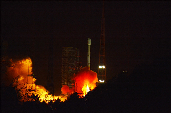
A Long March 3B rocket lifts the satellite from the Xichang Satellite Launch Center in Sichuan province at 12:04 am into the geosynchronous orbit. [Photo by Zhao Zhuqing/People's Daily Online] |
China launched an observation satellite early on Tuesday that will provide weather forecasting, and images and data from across Southeast Asia for forest monitoring, disaster prevention and other missions.
A rocket lifted the Gaofen-4 Earth satellite from the Xichang Satellite Launch Center in Sichuan province just after midnight and placed the 5-metric ton spacecraft into orbit. The mission marked the 222nd flight of the Long March rocket family.
After a six-month, in-orbit test, Gaofen-4 will provide images to the Ministry of Civil Affairs, the State Forestry Administration, the China Earthquake Administration and the China Meteorological Administration, according to the State Administration of Science, Technology and Industry for National Defense, which is in charge of China's space programs.
Images obtained by the satellite also can also be used in agriculture, land and water resource management and oceanic surveys, the administration said.
Tong Xudong, a senior official at the administration who oversees the Gaofen program, introduced the Gaofen-4 project in December 2012. The satellite was developed by the China Academy of Space Technology in Beijing.
"The Gaofen-4 is able to cover China and the whole Southeast Asia and can shift among multiple targets in a short period of time. It is capable of monitoring a designated area round-the-clock while sending back images in almost real-time," Tong told reporters before the launch.
Each of the satellite images can cover a 160,000-square km region, equivalent to the area of Henan province, said Li Guo, Gaofen-4's chief designer.
The ground resolution for the satellite's visible-light imager is 50 meters and for the infrared sensor is 400 meters. It has a designed life span of eight years, the longest of China's remote sensing satellites.
Gaofen-4 will work with the Gaofen-1 and Gaofen-2 to form a high-resolution Earth observation system that will greatly save manpower and prevent hazards as it can monitor places that are too dangerous or difficult for people to reach, Li said.
"For example, if the Gaofen-4 detects a forest fire, forestry authorities can receive the fire images very quickly and then mobilize the Gaofen-1 and Gaofen-2 to take clearer pictures of the affected areas. Without these space assets, we would have to send in firefighters to check what is happening," Li said.
China launched the Gaofen project in May 2010 and has listed it as one of the 16 most important national projects in science and technology.
The first in the system, Gaofen-1, was sent into space from the Jiuquan Satellite Launch Center in the Inner Mongolia autonomous region in April 2013. Other Gaofen satellites were launched this year and last.
The Gaofen-3 and Gaofen-5 missions are due next year, the administration said.
- Hanoi protest over test flight rejected
- PLA 'needs to boost its readiness'
- Govt mulls making retirees pay health insurance
- Watch this space: Telescope releases mass of data
- Beijing to work with neighbors to improve water quality
- China steps up crackdown on food and drug safety crimes
- Phones and drones - China's risk-takers who rule the world
- Rescue work continues to reach trapped miners
- China's 2nd aircraft carrier totally different from Liaoning
- Structural reform to power China's stable growth: Finance minister


