Exposing the beauty and mysteries of Changbai Mountain
Updated: 2015-10-06 08:32
By Liu Mingtaiand He Na(China Daily)
|
||||||||
 |
|
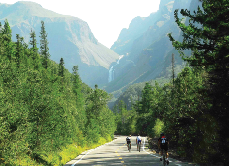
The Changbai Mountain reserve is a paradise for winter sports lovers and is home to one of the nation's best ski resorts. [Photo provided to China Daily] |
Greater accessibility
The Changbai Mountain range, which is shaped like a dragon, is located near Antu county of the Yanbian Korean autonomous prefecture in Jilin province, and borders the DPRK to the south.
Changbai Mountain, the highest peak, is an active volcano. At the top of the mountain is Tianchi, a crater lake that covers 9 square kilometers and is 2,194 meters above sea level.
Tianchi sources the Songhua, Tumen and Yalu rivers and has an average depth of 204 meters. It measures 373 meters at its deepest and the average water temperature is 7.3 C.
Years ago, visitors could only reach the mountaintop from the north from May to September as the rest of the mountain would be covered in snow. Today, however, with more scenery spots explored and the construction of infrastructure, visitors can climb the mountain at all sides except to the east, which lies with in DPRK territory.
It's hard to tell which is the best route as each route has a unique landscape. Visitors will likely need three days to explore all three routes.
The north route is the more traditional route where you can see a waterfall, an underground forest and hot springs. The 68-meter Changbai Waterfall is one of the highest volcanic waterfalls in the world. From afar, it looks like a white ribbon suspended in midair.
For elderly tourists, the north route is a good option as there are sport utility vehicle services that can take visitors to Tianchi.
Because of the high altitude, the weather changes from time to time at the top of the mountain-it's common for sunshine and rain to occur simultaneously.
- Russian warplanes hit IS targets in Syria
- Senior US envoy to visit Japan, S Korea, China
- Russia, US agree to cooperate in solving Syria crisis: Russian FM
- Iranian President calls Iran deal victory over war
- LatAm experts praise Xi on yuan, globalization
- Evidence found of summertime water flows on Mars: study

 China wins first Nobel in medicine
-
 Saving Chinese folk songs
 Candlelight vigil for Oregon shooting victims
 Chinese people's pursuits in different eras
 Ten highlights from Xi's trip to US and UN
 Top 10 life-changing benefits from Xi's US visit
-
 Highlights of President Xi's speeches at UN
 -
 The president's historic journey to the west
Most Viewed
Editor's Picks

|
|

|

|
|

|
Today's Top News
Tu first Chinese to win Nobel Prize in Medicine
Huntsman says Sino-US relationship needs common goals
Xi pledges $2 billion to help developing countries
Young people from US look forward to Xi's state visit: Survey
US to accept more refugees than planned
Li calls on State-owned firms to tap more global markets
Apple's iOS App Store suffers first major attack
Japan enacts new security laws to overturn postwar pacifism
US Weekly

|

|


