Deepest point on land found in Antarctica
By ANGUS McNEICE in London | China Daily Global | Updated: 2019-12-17 10:09


Discovery fills in gaps in understanding of what lies beneath frozen surface
An international team of glaciologists has recently identified the deepest point on land, hidden beneath the ice in Antarctica.
While working on a new topographical map of the most southerly continent, the researchers discovered that a trough underneath the Denman Glacier plunges to a dizzying depth.
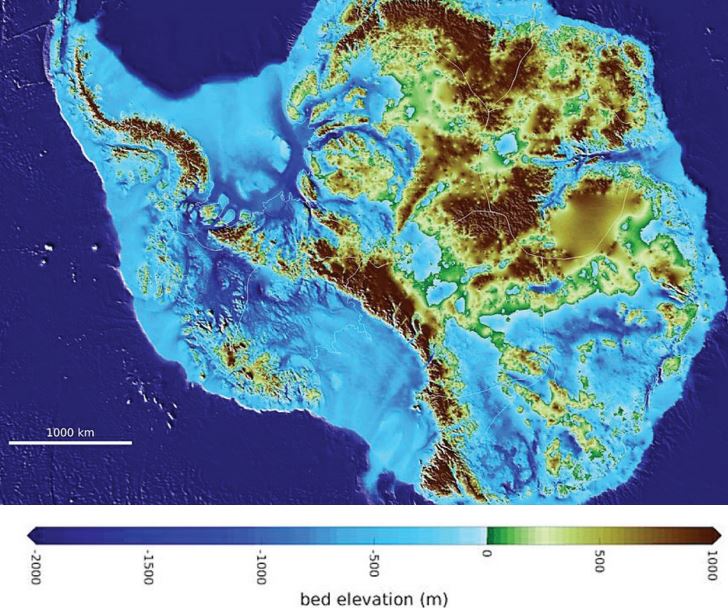
The large canyon, which is filled with ice, bottoms out at 3,500 meters below sea level. By comparison, the deepest lake bottom in a below-sea-level depression belongs to the Dead Sea, which is 750 meters below sea level at its bed.
Researchers from the British Antarctic Survey and the Polar Research Institute of China contributed to the new map of the continent, which is called BedMachine, as did scientists from polar research centers and universities in the United States, Germany, the Netherlands, Norway, India, France, Belgium, Denmark, Australia, and South Korea.
Mathieu Morlighem, an associate professor of Earth system science from the University of California Irvine, said previous depth estimates for the trough under the Denman Glacier were far shallower, and some researchers had questioned their accuracy due to the large quantities of ice that the glacier deposits on the coastline.
"Older maps suggested a shallower canyon, but that wasn't possible; something was missing," said Morlighem, who was lead author on the study that was published in the journal Nature."With conservation of mass, by combining existing radar survey and ice motion data, we know how much flows through the canyon- which, by our calculations, reaches 3,500 meters below sea level, the deepest point on land. Since it's relatively narrow, it has to be deep to allow that much ice mass to reach the coast."
To produce BedMachine, the team collated data from a number of sources, culminating in the most accurate portrait yet of the contours of the land beneath Antarctica's ice sheet. This involved inputting more than one million lines of radar readings taken during the last 50 years, as well as seismic information and measurements taken by satellites and aircraft during an 11-year polar survey conducted by NASA.
The resulting map has helped identify which regions of Antarctica are going to be more, or less, vulnerable to future climate warming, according to Tas van Ommen of the Australian Antarctic Division.
"BedMachine is a major step forward in refining the fine-scale topography hidden beneath the ice sheet, so that we can better model how it will respond to warming, and reduce the uncertainty in sea level rise projections," said van Ommen, who contributed to the study.
Since the Greenland and Antarctic ice sheets contain more than 99 percent of the freshwater on Earth, warming in the polar regions will have a significant impact on global sea levels.