Weather station on summit of Qomolangma upgraded
By Zhang Zhihao | China Daily | Updated: 2023-05-24 08:55

A team of Chinese scientists and climbers reached the summit of Qomolangma, also known as Mount Everest, on Tuesday, the second time since last year for the science expedition team to reach the top.
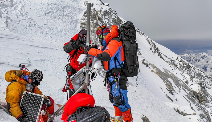
At around 12:30 pm on Tuesday, 13 Chinese scientists and climbers reached the peak of Qomolangma. They set off for the summit at an altitude of 8,300 meters at around 3 am on Tuesday and arrived at the 8,830-meter weather station after over eight hours of arduous climbing.
After fixing steel ropes, replacing batteries and installing wind speed and direction sensors, they completed upgrades to the weather station that was established last year. They also collected ice-snow samples on the summit for future analysis.
Last year, Chinese scientists set up the world's highest automated weather station, which records temperatures, humidity, wind speeds and other key data for studying climate change.
The latest climb was part of a comprehensive research expedition around the Qomolangma region that consists of 13 teams and 170 researchers. They will study the glaciers, ecosystems, human activities and other factors crucial for understanding the environment on the Qinghai-Tibet Plateau.
Given its massive glaciers, the Qinghai-Tibet Plateau is considered the world's "third pole "behind the Antarctic and the Arctic. In addition, the plateau is the source of many major rivers in Asia, including the Yangtze, Yellow and Yarlung Zangbo rivers, hence its nickname "Asia's water tower".
Climate scientists have found that global warming has had a disproportionate impact on the glacier population on the Qinghai-Tibet Plateau, according to the Institute of Tibetan Plateau Research of the Chinese Academy of Sciences.
Over the last five decades, the temperature on the Qinghai-Tibet Plateau has risen at a rate double the global average. From 1981 to 2020, temperatures in the region have been rising at an accelerated rate, at around 0.5 C every decade, according to the National Meteorological Information Center.
Studying the ecosystems of the Qinghai-Tibet Plateau will allow climate scientists to have a better understanding of the impact of climate change, and allow experts and policymakers to make informed decisions regarding biodiversity preservation and sustainable development, according to the institute.
Since the mid-20th century, China has launched various research expeditions to Qomolangma, but due to limited resources and technologies, most of the studies were done at an altitude of around 5 to 6 kilometers, and there was hardly any environmental data from above 8 kilometers, the institute said.
As a result, many key scientific questions were left unanswered, such as whether global warming can melt the ice at the top of Qomolangma, and how biodiversity, the ecosystem and composition of air pollutants can change as altitude increases to extreme heights.
China launched its first large-scale scientific expedition on the Qinghai-Tibet Plateau in 1973, with the goal of exploring and recording characteristics of the region. The second expedition, launched in 2017, aims to build on that foundation and figure out how these features change over time.


