Snow atop Qomolangma much deeper than thought
By Daqiong and Palden Nyima in Lhasa | chinadaily.com.cn | Updated: 2023-07-11 03:21


Snow: Depth survey took months of preparations
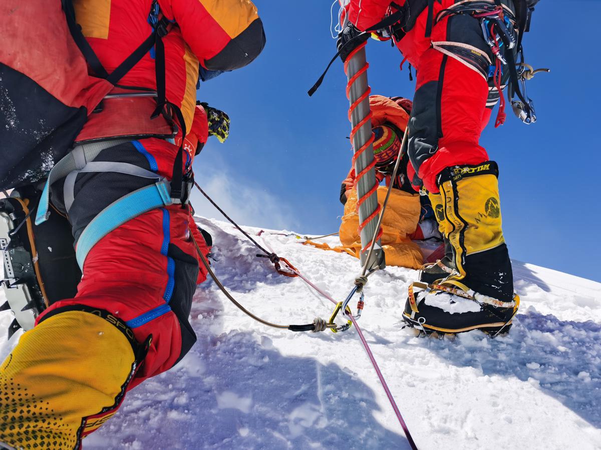
Chinese scientists who have measured the thickness of snow atop Qomolangma, known as Mount Everest in the West, using ground-penetrating radar said the mean depth estimates are 9.5 meters at the summit, with a margin of error of plus or minus 1.2 meters. Previous measurements had pegged the depth between 0.9 and 3.5 meters.
Scientists carried out the task of measuring the snow depth during China's second comprehensive scientific expedition to the Qinghai-Tibet Plateau in 2022. The survey results were published on Friday in the journal The Cryosphere.
The team conducted a series of surveys between April and May last year. Measuring the snow depth on the world's highest mountain was among its main tasks.
It is believed that the work of surveying the snow thickness on Qomolangma and noting its changes will be of immense scientific value in the study of global climate change. The subject is one of concern to both the scientific community and the public.
"The survey results will provide empirical support for the study of dynamic changes in the ultrahigh altitude cryosphere and the lithosphere at the top of Qomolangma, and also provide a new direction for a deeper understanding of ultrahigh altitude climate change," said Yao Tandong, an academician at the Chinese Academy of Sciences and team leader of the latest expedition.
Over the past five decades, multiples attempts were made to measure the snow depth at the summit of Qomolangma using different methods and instruments. The depth was determined to be 0.92 meters by Chinese climbers in 1975, was updated to 2.55 meters by a China-Italy joint climbing team in 1992, and then to 3.5 meters by Chinese climbers using radars in 2005. In 2019 and 2020, China and Nepal carried out separate surveys to measure the snow depth, but no results were published.
The latest expedition used a thickness-measuring radar to measure along the exposed bedrock near the top of the mountain, and gradually moved to the summit, said Yang Wei, a researcher at the Chinese Academy of Sciences' Institute of Tibetan Plateau Research. The new measurements indicate a gradual increase in depth along the northern slope, which made it easy for researchers to determine the snow depth with a 1.2-meter margin of error, Yang added.
The Cryosphere paper said the ground-penetrating radar survey was conducted with a single transmitter-receiver antenna at a frequency of 1,000 megahertz. For all GPR measurement points, a portable global navigation satellite system continuously recorded the antenna locations.
"Radar was not available decades ago. For the latest measurement process, a lot of preparations were made. While the actual measuring process would have taken about half an hour, the preparations took much longer," said Yang.
For the latest survey, tests were conducted in some glaciers and rivers around Lhasa, capital of the Tibet autonomous region, to ensure that the radar battery operated normally at altitudes ranging from 7,000 to 8,000 meters above sea level, he said. "It took months of preparations this time, which helped ensure normal measurements could be taken at high altitudes more accurately," he added.
"As the pinnacle of the world, the depth of snow atop the Qomolangma has been of much interest all over the world. The change in snow thickness provides accurate base data for studying future climate change," he said, adding that without this data, it is impossible to determine whether the snow depth is increasing or decreasing.
He said that previously used methods mainly focused on surface measurements, and the results were difficult to interpret on radar. Radar profile measurement methods were used this time.
"We cannot say the past results are wrong. The latest results are from 2022, while the previous measuring was conducted in 2005. There will be changes in snow coverage over the next 20 years," he said, adding that the Chinese scientists have come up with more precise measurements this time.


Editor's Pick