Located to the northwest of Guangdong in the middle reaches of the Xiaobeijiang River, Yangshan, known then as “Yangshan Pass”, was set up as a territory at the end of the Qin Dynasty. It became a county more than 2,200 years ago during Emperor Gao’s reign in the Western Han Dynasty (206-195 BC). In 1958, it was merged with Lianxian, Liannan and Lianshan into Lianyang Minorities autonomous county. In 1960, Yangshan county once again made a county in its own right and was brought under the jurisdiction of Shaoguan city and Qingyuan city, respectively. The county has a total area of 3,418 square kilometers and administers 13 townships and towns (Chengjia is a Yao autonomous township) and 167 village committees. By the end of 2009, the county had a total registered population of 536,400 people. The county government is located in Yangcheng town.


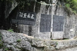
The cliff inscriptions in Xianling Mountain (L)
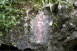
Han Wengong Reading Platform (R)
The county has rich resources with more than 30 kinds of mineral resources, including iron, lead, zinc and coal. The area has 327,000kW of water resources, including 242,000kW of developed water resources. The annual power generation can reach as much as 800 million kilowatt/hour. The county is at the forefront among counties in China in terms of installed capacity and power generation of small hydropower stations, and has received the title of "Land of Rural Hydropower in China”. It has 2.44 million hectares of provincial-level ecological forests and is the county with the largest area of ecological forests in the province. Its characteristic agricultural products include Chinese wild yam, chestnut, Yangshan chicken, silkworm cocoon and high-quality fruit. The area has received the titles of “Home of Chestnut in China”, “Home of Chinese Wild Yam in China”, “Home of Yangshan Chicken in China” and “Green County in Guangdong”.
 |
| Shenbi (Magic Pen) Cave |
Yangshan has typical karst landforms. The mountains stand raised up like a forest. The waters are beautiful. The natural attractions include the “Roof of Guangdong” (Guangdong First Peak) 1,902 meters above the sea level, the scenery around the Xiaobeijiang River, forest hot springs, Yulong Palace and Shenbi (Magic Pen) Cave. Cultural attractions include the cliff inscriptions in Xianling Mountain, Han Wengong (or Han Yu, first among the "Eight Great Prose Masters of the Tang and Song") Reading Platform, Yuanlan Pavilion, Qianyabiao, Rest Cave, Fishing Platform, Beishan Ancient Temple, Han Yu Memorial Hall and a famous overseas Chinese’s former residence – Xuefa Ancestral Hall.
 |
| Guangdong First Peak, 1,902 meters above the sea level |
Infrastructure facilities constantly improving, making the area even more accessible; No.107 and 323 national highways and No. 260, 114 and 347 provincial highways form a network, making the county easily accessible to the outside world. Cement highways link counties and towns or townships and all villages are connected by road. The Xiaobeijiang River is navigable by 150-tonnage cargo ships and links Qingyuan to Guangzhou. Substantial improvements in the area have also been achieved thanks to the penetration of communication technologies into the mountainous areas. Mobile communication networks cover the whole county.