County linked at last with outside world
By Wang Huazhong, Liu Xiangrui and Daqiong ( China Daily ) Updated: 2013-08-07 07:40:03
|
 |
|
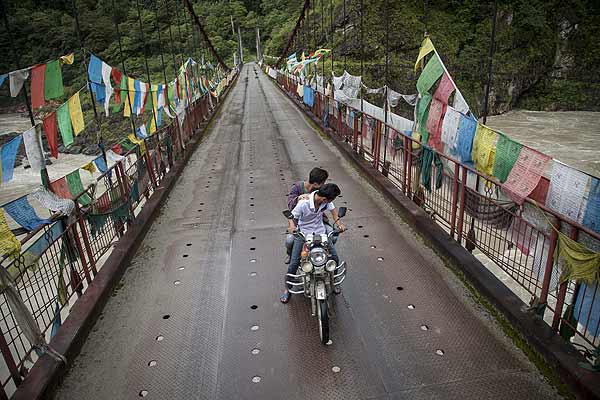
A motorcyclist and passenger ride across the bridge over the Yarlung Zangbo River in Dexing township of Medog county in the Tibet autonomous region. [Photo by Kuang Linhua/China Daily] |
Road provides a lifeline and lifts hopes for locals, Wang Huazhong, Liu Xiangrui and Daqiong report in Medog county, Tibet.
Few people understand the importance of roads better than the residents of Medog county in the Tibet autonomous region.
Nestled below the snowcapped peaks of the Himalayas and with the raging Yarlung Zangbo River running through it, the county is the last in China to be connected to the outside world by paved road. The Zhamog-Medog motorway is now fully operational, but only seasonally.
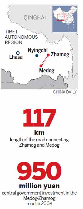
The road starts high in the frigid mountains at an elevation of more than 4,300 meters, before dropping sharply to the tropical atmosphere of the county seat, which sits at 1,100 meters.
Before 2010, the first 80 km section was closed in winter because of heavy snow and frequent avalanches. However, the second 37 km stretch was closed in summer because heavy rains often caused landslides. When one section was closed, goods were stored at a warehouse between them.
Both sections are now open at the same time for about eight months of the year.
The county did not have a post office until 2009, or an electronic appliances store until 2010. An ATM, and business administration and taxation bureaus, arrived in 2011. There is, as yet, no bus station.
The road, constructed against a backdrop of constant challenges, has not only brought to an end the traditional method of carrying goods into Medog, by foot or on horseback, but also, and more importantly, has brought hope to local people.
"From age 12, I used to spend eight days with my family carrying salt, oil and cloth to Medog from the adjoining county," said 71-year-old Sangye Dorje, a member of the Monba ethnic group and a qualified medical practitioner.
"Once, my companions became snow-blind. I took care of them, even though I had no shoes. Look at my rotten feet and upturned toenails. What would we have done if we hadn't built the road?
The central and local governments have been trying to make Medog accessible for several decades. In 2008, the State Council invested 950 million yuan ($139 million at the time) to upgrade the road. At the end of 2010, a tunnel was bored through Galung La Mountain, meaning the road is now passable eight months of the year.
The recent developments in the transport infrastructure have also spurred the local economy to the extent that in 2012 Medog generated GDP of 240 million yuan ($39 million), almost three times more than in 2008.
The same year saw the county attract the largest volume of inward investment among all the counties in Nyingchi, paying 138 million yuan in taxes, a rise of 452 percent from 2011.
"Without the road, everything is empty talk. Only when a road exists, can we realize our dreams," said Liu Gesheng, the former Party head of Medog.
"Medog is turning from an isolated island into a land of opportunity," he said
The 'elusive lotus'
Medog, which sits on the border with India, means "elusive lotus" in the Tibetan language. It is said that Padmasambhava, a guru who is also known as the Second Buddha, practiced in the county and spread the word. The sutra Kangyur describes Medog as "the most exceptional and blissful among holy sites" and explains that the county has an endless supply of food and holds the golden key to the blissful land.
Despite that praise, the lives of the local people haven't always been as rich as those described in the sutras.
The county annals show that until 1951 Medog was under the administration of the Sera Monastery, about 500 km away in Lhasa, meaning that residents were forced to pay tributes, including food, dyed goods and animal skins, to the monastery's deputies.
Locals had to walk through the tropical forests of Beibeng village (elevation 600 m) and pass over mountain peaks, such as the 4,200-m-high Doxong La Mountain, to hand over their tributes in the adjoining county of Mainling.
The 100-km tribute route, dubbed the "Monkey Pass" by locals, took 15 days to traverse on foot. It was no cakewalk; the bridges were simple chain devices and footholds in the cliffs were made by driving pieces of wood into crevices.
From 1962 to 1964, locals and soldiers worked to expand the pass into a 1-m-wide horse track, shortening the journey time to eight days. At the time, however, few locals could afford to own a horse.
"Everyone was in a jubilant mood and drank to celebrate having such a good road," said Sangye Dorje, who, in addition to his medical duties, is also a co-author of the county annals.
|
|
|
|
|
|
|
|








 Op Rana
 Berlin Fang
 Zhu Yuan
 Huang Xiangyang
 Chen Weihua
 Liu Shinan