Best of geology, topography, botany & anthropology
By LI YANG | CHINA DAILY | Updated: 2022-06-03 07:42


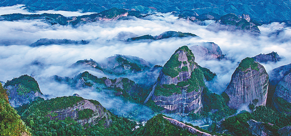
Villages are often named after the mountains they are perched upon, but Bajiaozhai, or a village having eight horns, in Ziyuan county of Guangxi Zhuang autonomous region and neighboring Xinning county of Hunan province, is a pseudo-karst mountain range with eight peaks featuring Danxia landform, or steep red cliffs.
The karst topography is common in areas underlain by limestone, but in Danxia it is formed from red-colored sandstone and its conglomerates. And they were both formed by endogenous forces, including uplift, and exogenous forces, including weathering and erosion.
Although two out of the eight peaks are located in Ziyuan and the other six in Xinning, more than half of the Bajiaozhai zone (or 125 square kilometers), which is also called Yuntai Mountain, stretches into Ziyuan on the Guangxi side, and less than half of it (108 sq km) into Xinning.
As another tourist spot in Jiaozuo, Central China's Henan province, bears the same name of Yuntai Mountain, the eight-peak mountain stretching across Guangxi and Hunan is better known as Bajiaozhai in the country.


Editor's Pick