Storm kills two amid evacuations in Japan
By WANG XU in Tokyo | China Daily Global | Updated: 2022-09-20 09:42


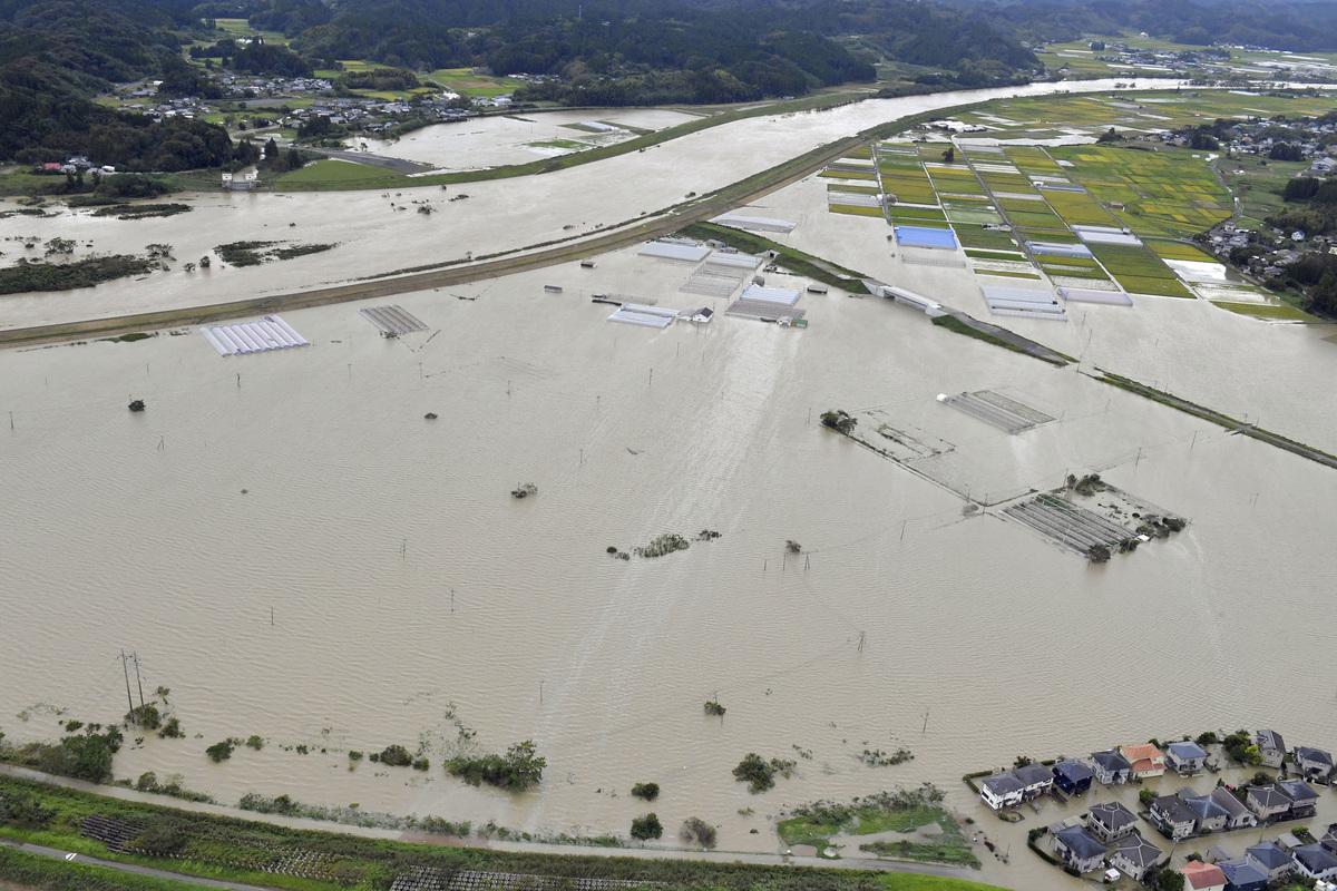
Typhoon Nanmadol, the fourth strongest to hit Japan in history, is now heading westward to Osaka, Kyoto and Tokyo as it lashed Kyushu island, killing at least two people, triggering heavy rain and floods, and causing millions to evacuate to safety.
The typhoon, which is also the 14th one to hit Japan this season, made landfall in the southern Kagoshima prefecture of Kyushu on Sunday night, said the Japan Meteorological Agency as the government issued an evacuation order for more than 9.7 million people across 14 prefectures.
On Monday, the agency said Nanmadol was now moving northeast at a speed of 15 kilometers per hour with a central atmospheric pressure of 975 hectopascals and a maximum wind speed of 108 km per hour. If so, the storm is expected to reach the capital Tokyo on Tuesday.
At least two people were killed by the storm, with one person found in a car that had been submerged in Miyazaki Prefecture, local media reported. Public broadcaster NHK said more than 100 people were injured.
Meanwhile, the typhoon had also triggered heavy rain, floods and landslides, leaving some 300,000 households without power around noon on Monday in Kyushu, the Kyushu Electric Power Transmission & Distribution said.
In Miyazaki city, the walls of the third and fourth floors on one side of a four-story building broke away.
"I heard a thumping sound and the building was shaking," a 78-year-old woman told NHK. She lives on the first floor of the building.
Her 73-year-old husband who runs a barber shop could only sigh.
"I will think about what to do with my shop after things settle down," he said.
Trip postponed
In wake of the storm, Japanese Prime Minister Fumio Kishida was to leave Japan on Monday to attend the United Nations General Assembly in New York. But he had to postpone his trip.
According to an analysis by the JMA, Nanmadol will weaken into an extratropical cyclone by Tuesday night off the east coast of Japan, but wide swaths of the nation will likely feel the effects of the storm.
Rain from the typhoon is expected to be heavy and intense through Tuesday. The JMA forecast estimated up to more than 400 millimeters of precipitation in the 24 hours to noon on Tuesday in some locations in the Tokai region, and 300 millimeters each in the Kansai and Kanto-Koshin regions.
"The thick cloud and eye area around the typhoon's center have already disappeared and it is weakening rapidly," Ryuta Kurora, head of the JMA's forecast unit, told reporters on Monday. "But soil is still accumulating. A lot of water, and slopes could collapse even though the rain has stopped."


Editor's Pick